Surf Report for the weekend of the 25th and 26th of January

East Coast

So normally the east coast gets a nice hit in the aftermath of a storm with the large pulse of swell coming up the east coast but as there is a second storm front coming in for Sunday, it is showing that Saturday will probably not break above 1-2ft despite the 11 second period. This could be ok for anyone super keen. The winds are moderate offshore in Wicklow. Sunday sees another storm front pass over but this time the winds are turning to hit the east coast from the south east which will bring waves but with the winds exceeding 50mph onshore, I am going to recommend giving it a miss as the amount of swell and current moving are too dangerous to support going for a surf.

South Coast

Tramore is looking like it could have a really nice period of good waves on Saturday morning but be mindful that these waves are coming off the back of a storm with no offshores so there will be a large amount of chop on the waves but waves none the less and light winds in the morning up until lunch when the winds turn direct south and the gusts and main winds start to grow ahead of the second storm coming. Sunday turns to a no go, so avoid.

South West

Garretstown sees similar light winds on Saturday morning which should bring some nice 6ft+ waves with that 13 second period but as Garretstown is further west than Tramore, the winds are picking up in strength and kicking in earlier so get on it early . Sunday is a write off so make the most of Saturday. Inch Beach in Kerry does not let up after the first storm with the west more exposed to the winds so both Saturday and Sunday are a no go.

West Coast

Lahinch sees a very small window on Saturday morning where the winds let off for a small period but this is coming off the back of onshore so expect bumpy conditions with the waves well overhead so this should be for the experienced only but with the winds, I would expect experienced surfers to give it a miss. Winds are good up until around 3pm when they turn onshore and the second storm comes in. As the storm is whipping around, it is actually showing offshore conditions for Lahinch but the strength of the winds is the concern with the main winds blowing at around 30mph (50kmh) with gusts up to 50mph (80kmh) so I would not recommend it unless you are local and find that the winds are much lighter than forecast and even then I would recommend caution as they can easily pick up while you are in the water and returning to shore would then become an issue and trying to paddle against 80kmh gusts is not possible. Tides are high at 2.30 Saturday and 3.30 Sunday so allow at least 2 hours before to exit the water.

North West

Strandhill looks like it could be quite large on Saturday due to the large swell and period forecast so I would be looking for spots that could kill off some of the size like Streedagh but this could still be quite dumpy. Other alternatives would be Aughris or Rossnowlagh. Aughris could have offshore winds and 2ft waves with Rossnowlagh showing bigger on Saturday but the winds are not ideal at crossshore. Sunday sees the winds pick up quite significantly so I would recommend giving it a miss as the strength of the winds peaks at midday with gusts up to 50mph for the whole of the day.

North Coast

Portrush sees some clean conditions on East Strand all day on Saturday but the swell is chunky and could have some decent reform waves on the inside but some of the waves out the back will be over 6ft with the 12 second period. Winds are moderate offshore for Saturday. Sunday sees the winds pick up and come from the south east which, while offshore for some spots like West Strand, I would predict these to be too strong unless there is some land drag but West Strand would be the only option for Sunday but exercise extreme caution before getting in the water as the gusts are up to 50mph by 3pm.

Surf Safe and Enjoy,

Col

Surf Improvers

Surf Report Warning

Friday 24th of January

With the onset of Storm Éowyn and the large window of impact, I can only plead with surfers to avoid the coast during the storm warning windows and in the periods both before and after the main peak of the storm. Please do not put yourself or the brave volunteers of the RNLI at risk.
The one thing that can be guaranteed is that there are plenty more waves in the sea and skipping this one day will ensure the safety of all.

Col

Surf Improvers

Surf Report for the weekend of the 18th and 19th of January

East Coast

Surf on the east coast is looking like there could be some wind swell 1ft conditions which won’t really have a lot for improvers as the period is only a wind swell 5 seconds on Saturday with the winds moderate from the south blowing around the 25mph mark. On Sunday the swell remains around the 1ft mark with a slight drop in swell but slight increase in period so still only 1ft but with slightly less wind from the south coming in at less than 20mph.

South Coast

Conditions around Tramore are looking onshore with the south wind offering no shelter along the coast with both Saturday and Sunday seeing winds from 15-25mph onshore. Waves on Saturday should be in the 2ft range blown over with Sunday showing 2-3ft blown from the back with small periods only really good for lessons.

South West

Garretstown is also looking blown onshore for Saturday and Sunday with the winds making it messy on both days with 15-25mph onshore. Waves should be in the 3ft blown over Saturday and similar for Sunday. Inch Beach in Kerry is showing a decent swell and period but this looks to be exposed to the winds which are showing up to 40mph gusts down that side of the country but this will probably be lighter in reality but still not in the right direction to bring clean conditions. Expect large cross shore conditions around the 6-8ft mark with messy conditions making it best to give it a miss Saturday. Sunday looks like the winds completely back off but the swells could be too big for Inch so explore the north side of the peninsula where the swell should be reduced significantly and could bring smaller swells to around the west side of Brandon Bay with it smallest at Fermoyle working around.

West Coast

Lahinch has had some really nice swell over last weekend and on into the week with this weekend showing some decent swells with the wind gusts possibly a little on the strong but this may reduce with land drag. Saturday is showing 5-6ft conditions with the winds blowing best for the south end of the beach. Sunday sees those winds drop off to bring near excellent conditions with the waves around the 6ft mark with light winds less than 10mph, a little onshore but not enough to bring anything other than a slight bump to the waves. Care should be exercised though as the period is up to 16 seconds which may bring large lulls between the sets and then the sets will come through which could make those 6ft sets even bigger. Tides are high before first light Saturday leaving the whole day free to surf with high at 8am Sunday meaning you will need to wait until it drops off the rocks to get in but then you have the full day to surf.

North West

It has been cooking in the Bundoran area all week with waves through all tides and it looks like it is due to continue into the weekend with a touch of south in the swell again for this weekend which will struggle to light up some of the north facing spots which could mean only 2ft conditions for Strandhill and possibly up to 3ft as the period does hit 13 seconds on Saturday with the winds quite gusty up to 30mph. Sunday sees the winds drop right back and the swell jump significantly in size which will max out the likes of Strandhill but could bring spots like Enniscrone or Streedagh to life with a big 16 second period which means big gaps of nothingness in between sets and then the sea will just come to life. Winds are light offshore for Enniscrone and Streedagh with the winds looking to be less than 10mph for the most with gusts dropping as the day goes on. In the Bundoran area it is going to mean that it will be a Tullan day Saturday but it could be quite bumpy with those winds Saturday but then Sunday will max out Tullan leaving some really nice conditions for the likes of Rossnowlagh on Sunday which could see 5-6ft conditions with light winds with the better winds later in the day when the gusts fall away.

North Coast

Portrush does not look to share the spoils this weekend with the forecast only showing 1-2ft for Saturday with the winds blowing moderate to strong offshore for the likes of East Strand. Sunday looks like it could get up a little better with the bigger period but will still probably only hit 2-3ft with offshore winds that start a little gusty but drop off later in the day as the swell also builds so if you are local and can keep an eye on the spots, it could be good at West or Whiterocks as there is quite a bit of West in the swell and the winds drop very light the later you leave it. Just watch that last light!

Surf Safe and Enjoy,

Col,

Surf Improvers

Surf Report for the weekend of the 11th and 12th of January

East Coast

Saturday is looking like it is not going to break much above the 1ft mark with only a small swell coming up the channel. Winds are coming up from the south also but not enough to drive the swell to bring anything over 1ft. Sunday looks to be smaller again with only less than 1ft coming through with a moderate southerly wind all weekend.

South Coast

Saturday is looking really nice for the longboards in Tramore with a smaller 2-3ft wave coming through with a nice 9 second period. Winds are light offshore all day with the best winds coming around 9am but the winds are nice and light all day. Sunday sees the winds turn onshore for the day so it would be Saturday as the best chance for nice clean waves over the weekend. Waves on Sunday are 2-3ft but the onshore winds will make them messy versus the offshore conditions on Saturday.

South West

Conditions in Garretstown are looking really nice for Saturday with the waves showing 4-5ft with light cross offshore winds but these look nice and light with even the gusts barely breaking 10mph so this should be really nice. Some of the sets will break bigger with the 13 second period so expect some really good waves. Sunday sees the winds turn onshore and pick up quite strongly so make the most of the waves on Saturday. Inch Beach in Kerry is showing some bigger conditions with light onshore winds but I would expect the beach to take some of this size out of the swell with it forecasting up to 8ft plus but I would really expect this to be 5ft plus with light onshore breezes with the winds lightest in the morning before it turns southerly which could bring a little bump to the waves. Sunday sees Inch turn moderate to strong cross shore which will make for bumpy conditions so get out on it Saturday.

West Coast

Lahinch has been forecasting much bigger than hand been appearing on the swell and Friday was no exception with the forecast showing 4-6ft with only 2ft showing up so this is making it hard to predict for the weekend but if I use the same scale then I would expect 4ft conditions for Saturday with the winds blowing light from the south which will favour the south end of the beach with light cross offshore conditions with a small bump but this should be nice waves for Saturday with Sunday look to have the winds pick up and possibly blow the 2ft waves out to sea despite the forecast showing 5-7ft conditions but I would expect 2ft with moderate to strong cross shore winds making for bumpy conditions. Tides are high at 3pm Saturday and 4pm Sunday so out of the water by at least 1pm Saturday and 2pm Sunday as the tides are bigger tides and will rush in a little quicker.

North West

Strandhill is looking nice for Saturday with the winds blowing light offshore all day and less than 10mph. The problem is that the waves forecast have a lot of south in them which always struggles to get into Strandhill and will favour spots like Tullan better. So while the forecast is for 3-5ft waves for Strandhill, these should look more like 1-2ft at best. Sunday sees a little more west in the swell but this will probably only bring some of the 2footers into the bay but this will probably be the max of it but the winds really pick up on Sunday to nearly 30mph offshore so best to get out Saturday on the foamie or longboard and have some fun before the winds blow into your face. Around the Bundoran area it is looking like the southerly swell that misses Strandhill will break into Bundoran and bring nice 3-4ft conditions on peak one of Tullan Strand with 2-3ft for the rest of the beach with light offshore winds all day. Sunday sees the winds really pick up so go for Saturday or as early as you can Sunday before the gusts start to ruin play.

North Coast

In the north of the country the swell looks like it is being blown away from the land by the moderate southerly winds making for swell that will struggle to break over 1-2ft on any of the spots around Portrush with the best chance of waves being on Whiterocks or East Strand where the land drag may slow down that offshore wind.

Surf Safe and Enjoy,

Col,

Surf Improvers
Surf Report for the weekend of the 4th and 5th of January

East Coast

Conditions in Wicklow are looking small to flat for Saturday with little to no waves. Sunday sees a northerly swell come along that is driven by a moderate north westerly wind which will bring icy onshore conditions to Wicklow with 2ft waves at best as this is driven by the onshore winds. Conditions will not be great but it will have a small messy wave for those keen.

South Coast

Tramore has had some nice waves over the last few days and this looks set to continue with Saturday morning having some nice conditions with light winds up until midday when things look to pick up and turn light to moderate cross onshore from the south east. Waves should be in the 2-3ft range with best conditions early on. Sunday sees the north westerly wind which which bring nice offshore conditions and some chunky swell for the south coast with 5-6ft waves and offshore winds all day. Winds are best around midday but I’d recommend earlier for better waves.

South West

Waves around Garretstown look to be a little messy on Saturday with the winds looking to blow mostly from the south east bringing cross offshore conditions with waves in the 2-3ft range before jumping up on Sunday to 6ft plus with sets breaking bigger up to 8ft with moderate to strong offshore conditions so some great waves for the improvers and experienced surfers out there.
Inch Beach in Kerry looks to have offshore winds all weekend but the swell has a lot of south in it meaning that it should get in and bring 2-3ft conditions for Saturday with moderate offshore winds and then Sunday should see the waves pick up to 4ft plus but the winds also pick up to turn cross offshore from the north west bringing chilly offshore winds up to 35mph plus.

West Coast

Lahinch looks to be offshore all weekend with the lighter winds being on Saturday with the swell only looking to be in the 2ft region Saturday. Sunday sees it start out with a north west swell first thing before turning to a south west. Waves should be in the 2ft region again and possibly bigger on the tides with the winds being moderate offshore in the high teens gusting up to 30mph at times. Tides are high before 8 in the morning Saturday and at 8:30 Sunday so wait until the waves drop off the rocks and you should be good to surf all day until dark.

North West

In the Strandhill area it is looking like the waves will be a clean with light winds Saturday and waves in the 2ft region with bigger on sets as there’s a good 11 second period behind the waves. Winds are light offshore all day Saturday. Sunday sees the winds turn from the north west bringing cross shore conditions which will be a little bumpy but mostly offshore but a little strong to keep you out of the wave. This will not suit the north facing spots at all. Waves in Strandhill will be around the 3-4ft mark but the winds will make them bumpy. In the Bundoran area the conditions should see Saturday bring 2ft with light winds Saturday which will probably be the best of it as Sunday brings 2ft conditions but the winds pick up to nearly 20mph offshore making for waves that will have a bit of bump to them. If the swell was a little bigger the winds would favour Rossnowlagh but the swell will probably be too small for any decent waves.

North Coast

Portrush probably won’t break 1ft on Saturday with light offshore winds all day with Sunday seeing the winds turn cross onshore for East and Whiterocks but offshore for West Strand. Any waves for West Strand will probably be blown offshore by the moderate to strong winds making for 1ft max conditions.

Surf Safe and Enjoy

Col

Surf Improvers

Surf Report for the weekend of the 28th and 29th of December

East Coast

Both Saturday and Sunday are looking small to flat on the east coast with no waves over 1ft coming into Wicklow. Winds are light offshore from the south west making for relatively calm conditions.

South Coast

Tramore is also looking very calm for the weekend with the waves not breaking much over 6” to 1ft and barely enough for a foamie. Winds are light onshore.

South West

Conditions in Garretstown might break the 1ft mark but with the small 8-9 second period, the conditions will be small and weak and will struggle to get very much push on the waves with the winds light onshore from the south west. Inch Beach in Kerry is showing a chunky north west swell which would normally struggle to get into Inch but with a good 14 second period, it should still bring 2-3ft conditions and possibly bigger on sets with light onshore winds for Saturday and stronger moderate onshore conditions for Sunday.

West Coast

Lahinch also struggles to let the north west swell in but with a good bit of push behind it and there being a god bit of west in the angle, some of the swell will get in but how much is the question with 6-8ft forecast but it will be nowhere near this with more likely 2-3ft with possibly bigger on sets and tides with the high tide in the afternoon around 3pm so best to get on it in the morning before it gets too high as the dark will not allow for waves after the high tide. Winds also turn onshore around lunchtime. Sunday sees similar conditions but the winds are much stronger for Sunday making for more messy onshore conditions gusting up to 30mph at times. Tide on Sunday is high at close to 4.30 but realistically with the conditions being moderate to strong onshore, it will be messy and you would want to be out of the water by around 2pm as the high is over 4m.

North West

Conditions around the northwest are looking chunky for the coming days with the north west swell getting in a little too easy to most spots with the better conditions being around spots that offer shelter from the swell with even the likes of Enniscrone being over 6ft and Streedagh probably being around 2-3ft and maybe bigger but dumpy but worth a look further up the beach but I suspect that it could take somewhere like Rossnowlagh to kill off some of the swell with even there pulling in 3ft waves and light winds southerly in the morning before turning onshore later in the day. The usual spots like Strandhill or Tullan will all be maxed out. Sunday is big and onshore for all spots leaving no surfable beaches.

North Coast

Portrush has been having a good run of waves with this set to continue but the waves are fairly chunky and only for the experienced as the waves coming through are well overhead with 6-8ft sets forecast for Saturday with a good chunky 14 second period with good wind conditions for East Strand until around midday and possibly a little cross shore for Whiterocks for the day. Sunday sees the winds pick up significantly leaving cross offshore conditions but probably a little too strong for anything decent.

Surf Safe and Enjoy,

Col,

Surf Improvers
Surf Report for the weekend of the 21st and 22nd of December

East Coast

While it is big and stormy on the west coast, it is looking like the east coast will not get any of the larger swells normally associated with the storms. Instead conditions will be 1-2ft at best Saturday in Wicklow with moderate to strong offshore winds all day. Sunday returns to being small to flat.

South Coast

Conditions in Tramore are looking like there is going to be plenty of swell with waves in the 3-4ft range but the winds are blowing directly onshore for most of the weekend making for smaller appearing conditions and messy waves. Saturday should see 3ft blown onshore conditions with Sunday sees the conditions change to 2ft with the winds turning to blow from the west north west making for cross shore messy conditions.

South West

The winds around Garretstown are going to make for blown out conditions with the gusts hitting up to 40mph direct onshore Saturday making for unsurfable conditions. Sunday sees more of the same but with the swell jumping up with the winds hitting nearly 50mph on the gusts. Inch Beach in Kerry will be maxed out both days so give it a miss.

West Coast

Lahinch is also going to be maxed out both days with no shelter along the coast from the large onshore winds and waves.

North West

Normally I would recommend a spot like Aughris but the winds and the waves are going to be probably bringing larger conditions to Aughris with the west winds offering very little shelter. There could be a wave on Mullaghmore Beach for those who are in the area and super keen but the winds are hitting gale force from the west so there will be very little shelter or enjoyment from the winds. Strandhill, Enniscrone, Streedagh, Tullan, Rossnowlagh etc will all be maxed out from the conditions so give it a miss this weekend.

North Coast

Portrush ended up having periods of good waves last weekend after me forecasting doom and gloom but the waves were not on offer all weekend so would only have suited those who were in the area and able to jump in at a moments notice as they did not last through the tides. This weekend is looking like it is also going to be maxed out with the large storm force conditions bring very little by way of shelter or respite from the winds and large waves with both Saturday and Sunday looking maxed out.

Surf Safe and Enjoy,

Col,

Surf Improvers

Surf Report for the weekend of the 14th and 15th of December

East Coast

Things are looking very small to flat for the weekend on the east coast. Winds are offshore all weekend but no waves for surfing.

South Coast

Tramore is also looking very small for the weekend with the conditions struggling to get above 1ft Saturday and Sunday may get up to 2ft but the period is very low which make for a very small weak wave with light onshore winds on both days.

South West

Conditions in Garretstown are showing 1-2ft for Saturday with onshore winds all day with Sunday looking a little better in the swell but it is also only getting that 5 second wind swell from the 10-25mph onshore winds all day so while it forecasts 2-3ft, I would be thinking that this should be more of the 2ft and weak blown over waves. Inch Beach in Kerry is showing a primary swell coming from the north west which will struggle to get into Inch but it also has north westerly winds making for messy 2-3ft conditions. Sunday sees more of the same but with the winds swinging to be south westerly onshore conditions but the primary swell is still north westerly.

West Coast

Around Lahinch it is again a north west swell which will struggle to get into the bay with 1-2ft and possibly bigger on sets but the north should kill off most of the swell opportunity. Winds are light to moderate onshore from the north west. Sunday is showing more westerly conditions which has a greater chance for waves with 3-4ft conditions but the winds are onshore so this may blow over the waves making it feel more like 2-3ft. Winds are up to 30mph on Sunday. Tides are high at 4.30 Saturday and 5pm Sunday but they are quite large high tides so at least 2 hours out of the water before high to ensure safe exit.

North West

The north west in the swell will actually get directly in to Strandhill but the winds are showing to be westerly also which may cause for cross onshore conditions. Waves should be in the 4-5ft region but with the onshore winds these will probably be messy and blown over but conditions are lightest during the middle of the day. Sunday is showing the winds to be much stronger onshore so expect similar 3-4ft blown onshore conditions with the winds up to 30mph onshore making for messy conditions. In the Bundoran area Tullan will be maxed out with the onshore winds leaving only Rossnowlagh as a safe option for those keen for a white water surf with 2-3ft conditions both days with winds gusting between 20 and 30mph both days onshore so really only for the keen.

North Coast

In the Portrush area the winds will be the killer with the north west winds blowing out all spots leaving no options for surf across West, East or Whiterocks with waves in the 3-4ft blown onshore Saturday and 2-3ft waves Sunday but these will probably be smaller due to the wind strength on Sunday.

Surf Safe and Enjoy,

Col,

Surf Improvers
Surf Report for the weekend of the 7th and 8th of December

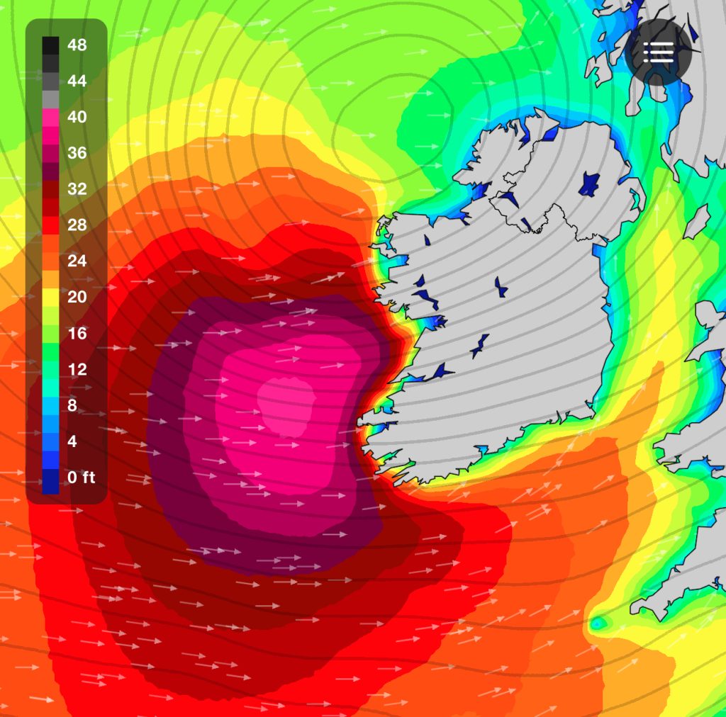
A foreword of warning. This weekend sees Storm Darragh come through. It has been upgraded to a Red weather warning for lots of counties around the country. Extreme caution should be taken before going in the water and only those who have experience of surfing storms of this magnitude should venture out and even then I would offer warning. Do not put the lives of the RNLI or others at risk as there are plenty more weekends and plenty more waves in the sea. Even after the storm, there will still be a lot of water moving around and it doesn’t look like the winds die down until Monday bringing some excellent surfing conditions to the west coast for all next week.

East Coast

With the incoming Storm Darragh there will be some strong to very strong wind conditions over the coming days with waves coming from two directions with a small southerly ground swell up to 14 seconds but this is too small for waves but may bring punch to some of the winds swell waves coming down the channel for a change. The waves coming down the channel are going to be coming after the storm with the conditions after the winds have died down to a a still very high 50mph plus so first thing in the morning may be just to dangerous . It should be noted that this is a strong storm and has been classed as a Red Weather warning and care should be exercised if going in the water as the conditions are going to be big and unruly and only very experienced surfers should go in the water. Waves from the north do not offer as much shelter from winds so there will be a lot of water moving around. It may necessitate getting out of the water to reposition as paddling against the current may not be available. Waves could be in the 3-4ft plus range bending into the beach from the north. Waves on Sunday will look like more of the same however it looks like there is more north in the wind meaning that conditions should be a little more cross shore turning onshore later on as the swell drops.

South Coast

Tramore will be blown out on Saturday and Sunday with the winds blowing direct offshore making for dangerous conditions.

South West

Garretstown is looking like it will be maxed out first thing Saturday and the winds don’t look to drop below 50mph cross shore so I would air on the side of caution and suggest giving it a miss. Sunday sees the winds continue with the northerly direction making it cross offshore but the swell is dropping from 3ft to flat later in the day as the winds blow the swell out to sea. Inch Beach in Kerry is a total avoid Saturday and the winds will not make for fun surfing Sunday as the north winds are cross shore with only a small hope of shelter at the north end of the beach under the cliff with 3ft bumpy conditions expected.

West Coast

Lahinch is looking maxed out Saturday so avoid with Sunday showing a swell coming in from the north which will struggle to get into the bay with moderate to strong offshore winds with the best chance for waves early on Sunday but the tide is looking to hamper this with the high not dropping off the rocks until before 12 so it could be too late and the swell too small at that point. Lovely clean waves all week after the storm if you’re in the area!

North West

Strandhill is looking maxed out until well into Sunday as the storm needs time to pass until Sunday evening when the swell calms down but the winds are moderate from the north at all times offering no shelter. Streedagh would have a wave on Sunday after the storm but the north winds will make for messy onshore conditions. In the Bundoran area, everywhere will be maxed out with Sunday offering the best chance of a wave at Rossnowlagh where it will be cross offshore but the winds will be moderate to strong so care should be taken with your board and when crossing the sand. It also looks like the north west will have some excellent conditions all week from Monday onwards.

North Coast

Portrush has had some nice waves Thursday and Friday but it looks like the winds from the north will leave all spots too strong onshore and with big swells making it one to skip.

Surf Safe and Enjoy,

Col,

Surf Improvers

Surf Report for the weekend of the 30th of November and 1st of December

East Coast

It looks like there will be waves this weekend on the east coast but the winds are not favourable on Friday with the winds blowing from the south east which is going to bring onshore conditions. Saturday should see 1-2ft conditions with moderate to strong winds from the south which will mean cross shore bumpy conditions with a small bit of shelter at the south end of the Wicklow beaches. Winds look to be up to 45mph on the gust on Saturday and up to 30mph on the gusts on Sunday but Sunday sees a little more west in the winds making it a little more offshore but waves will probably only be in the 1-2ft range and weak with the 6 second period.

South Coast

Saturday is looking like a write off with the conditions being strong onshore leaving no shelter anywhere. Sunday looks to have onshore winds all day too but a little lighter than the Saturday but still messy until the evening time when the winds look to drop back a bit but the two plus days of onshore winds will mean the waves will still be messy.

South West

Garretstown is also looking like it is going to have messy conditions all weekend with the winds blowing direct onshore into the bay making for no waves for improvers. Inch Beach in Kerry is looking big and messy all day Saturday with the winds blowing moderate to strong from the south with Sunday seeing the winds turn more onshore making for unsurfable conditions on both days.

West Coast

Lahinch is showing cross shore conditions all day Saturday with the winds blowing 17-30mph from the south making for cross shore bumpy conditions with the waves in the 3-4ft range blown over. Sunday sees the winds turn more onshore making even less favourable conditions. Tides are high at 5pm Saturday and after 5 Sunday so this only rules out the end of the day but with the winds and conditions, it will not matter.

North West

Conditions around Strandhill are showing good on the charts but the winds are up to 30mph+ so I would expect this to bring difficult surfing conditions with the possibility that the waves will be blown away from the land. There is a touch of south in the swell with only a small northerly meaning that it could well be small to flat. Sunday sees more south in the swell turning northerly later but this is when the winds turn onshore so this is only low period wind swell so the only hope is the first light southerly swell but this will be small in the 1-2ft. Around the Bundoran area it is looking like 2ft conditions on Tullan with the winds blowing moderate to strong cross shore making it ok for lessons but hard to find a clean wave anywhere. Sunday sees the period drop back meaning only 1-2ft conditions on Tullan. Rossnowlagh may be too small for waves with the winds being unfavourable even if it gets to 2ft.

North Coast

Portrush is looking small to flat for the weekend with very little incoming swell and moderate to strong offshore winds blowing any chance of swell out to sea.

Surf Safe and Enjoy,

Col,

Surf Improvers